A recent study from the University of California – San Diego has identified a significant factor affecting global agriculture: the origin of rainfall. Published in the journal Nature Sustainability, the research reveals how the sources of atmospheric moisture—whether from oceanic or land-based origins—impact drought risks and crop productivity.
The study, titled “Crop water origins and hydroclimate vulnerability of global croplands,” explores how atmospheric moisture is generated. When the sun heats various surfaces, water evaporates into vapor, which eventually returns as precipitation. Moisture from the ocean can travel vast distances, while land-based moisture—often referred to as recycled rainfall—originates from local sources like soil and vegetation.
Understanding this dynamic is crucial. According to Yan Jiang, the study’s lead author and a postdoctoral scholar at UC San Diego, the balance between ocean-sourced and land-sourced moisture plays a pivotal role in determining a region’s drought risk. “Our work reframes drought risk—it’s not just about how much it rains, but where that rain comes from,” Jiang stated.
New Insights for Drought Prediction
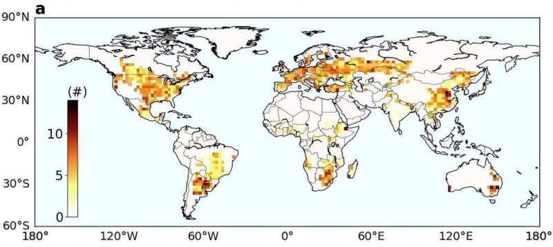
Utilizing nearly two decades of satellite data, Jiang and co-author Jennifer Burney from Stanford University analyzed the origins of rainfall globally. They found that when over one-third of precipitation derives from land, areas become significantly more prone to drought and reduced crop yields. This vulnerability likely stems from the fact that oceanic systems typically deliver heavier and more reliable rainfall, while land-sourced systems offer less dependable precipitation.
This information equips farmers and policymakers with a new method to assess drought risks more accurately. Jiang pointed out that regions relying heavily on land-originating moisture—including parts of the U.S. Midwest and East Africa—must manage local water resources carefully. Fluctuations in soil moisture or land use can have immediate negative impacts on crop yields.
Hotspots of Vulnerability
The study identifies two significant areas of concern: the U.S. Midwest and tropical East Africa. In the Midwest, drought frequency and intensity have escalated in recent years, raising alarms for one of the world’s most productive agricultural regions. Jiang noted that the Midwest’s reliance on land-sourced moisture may intensify drought conditions through “rainfall feedback loops.” As the land dries, evaporation decreases, leading to reduced rainfall and creating a self-perpetuating cycle of drought.
Given the Midwest’s crucial role in global grain supply, these disruptions could extend beyond U.S. borders, with potential impacts on global food markets. Jiang emphasizes that Midwestern farmers must enhance their soil moisture management practices, improve irrigation efficiency, and carefully consider planting times to mitigate drought stress.
In contrast, East Africa faces a more precarious situation. Rapid agricultural expansion and deforestation threaten vital moisture sources that contribute to regional rainfall. Jiang cautions, “Farmers are clearing forests to grow more crops, but those forests help generate the rainfall that the crops depend on. If that moisture source disappears, local food security will be at greater risk.”
Despite these challenges, Jiang sees opportunities for improvement. Implementing smarter land management practices, such as conserving forests and restoring vegetation, can protect rainfall patterns and support agricultural sustainability.
The research underscores the importance of forests and natural ecosystems in agriculture. Forests act as significant sources of water vapor, enhancing rainfall through evaporation and transpiration. Jiang notes, “Upland forests are like natural rainmakers. Protecting these ecosystems isn’t just about biodiversity—it’s about sustaining agriculture.”
This groundbreaking study provides a new scientific framework linking land management, rainfall patterns, and crop planning. The innovative satellite-based mapping technique could assist governments and farmers in identifying optimal investments in irrigation, soil water storage, and forest conservation, ultimately enhancing drought resilience and agricultural productivity.


