UPDATE: A severe winter storm is set to hit Western Colorado, beginning tonight and continuing through Wednesday, bringing heavy snow and dangerous travel conditions. The National Weather Service has issued a Winter Storm Warning effective from 11 PM Monday until 5 AM Thursday, impacting numerous mountain regions including the Grand Mesa, San Juan Mountains, and Vail Pass.
Travel disruptions are expected as snowfall accumulations will range from 10 to 18 inches in the mountains, with wind gusts reaching up to 60-70 mph, creating near-zero visibility at times. The storm could make travel through the mountains “difficult to impossible,” according to officials.
Areas affected include popular destinations such as Telluride, Ouray, and the Colorado National Monument. Travelers heading toward Salt Lake City should also prepare for significant delays.
Weather Alert: A Winter Weather Advisory is also in effect for surrounding regions in northwestern Colorado, including the Roan and Tavaputs Plateaus, with expected snowfall of 4-10 inches and wind gusts up to 60 mph. This will make travel challenging, particularly in the La Sal Mountains and eastern Utah areas.
Additionally, a Wind Advisory is in place from 5 AM Tuesday to 5 PM Tuesday for various valleys in Southwest and Northwest Colorado, including the Animas River Basin and Paradox Valley, where gusts could reach 50 mph.
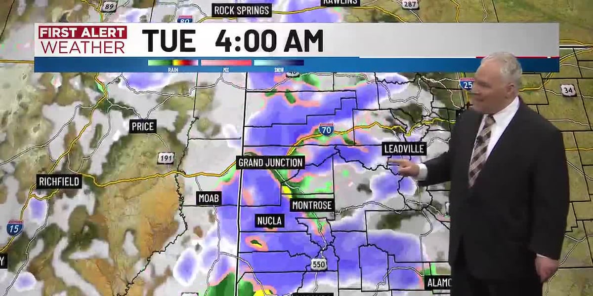
Timing of the Storm: The storm system will begin with valley rain and mountain snow moving through the area between midnight Monday and 6 AM Tuesday. On-and-off rain and snow are expected throughout Tuesday, with significant snow accumulation beginning between 2 AM and 6 AM Wednesday.
Snowfall totals through Wednesday could vary significantly. While valley areas might see little accumulation, the higher elevations are forecasted to receive up to 3 feet of snow, particularly near Wolf Creek Pass. Areas along and north of I-70 are expected to accumulate 5-10 inches by Wednesday afternoon.
As conditions worsen, Monday will remain cloudy but dry, with afternoon temperatures peaking near the low-to-mid 50s across the region. However, the upcoming storm presents an urgent reminder for residents and travelers to remain vigilant and plan accordingly.
What to Expect Next: As the storm progresses, another wave of precipitation is anticipated from 10 AM to noon on Wednesday, with further snowfall expected on Thursday and Friday. Weather patterns are projected to shift by the weekend, offering a respite from the intense winter conditions.
Travelers are urged to avoid unnecessary trips during the storm and stay updated on weather advisories. Authorities recommend checking road conditions and preparing for hazardous travel scenarios as this winter storm unfolds.
Stay tuned for more updates as this situation develops.