Severe Storm Complex Races Toward Tulsa With Damaging Winds and Tornado Threat
TULSA, OKLAHOMA — A powerful severe storm complex is advancing rapidly toward the Tulsa metro area as of 10:15 PM, bringing dangerous winds, intense rainfall, and the possibility of a spin-up tornado. Residents are urged to move immediately to interior shelter on the lowest floors of sturdy buildings and remain there until the system passes.
Forecasters emphasize that the most immediate threat is damaging winds capable of downing trees, knocking out power lines, and causing major structural damage across Tulsa and surrounding communities. Additionally, very heavy rain is expected to cause rapid flooding on roads and in low-lying areas, creating dangerous travel conditions.
Storm Track and Affected Areas
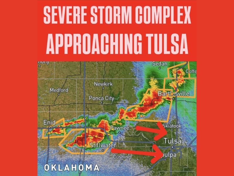
Radar shows two intense storm cells moving eastward directly toward Tulsa and nearby cities including Skiatook and Sapulpa. The storm complex currently impacts areas stretching from Enid through Pawnee and Stillwater, with a northern section active near Bartlesville and Washington County.
Red and orange radar returns indicate severe storm activity with one cell targeting Tulsa itself and another approaching Sapulpa just south of the metro area. These strong thunderstorms are advancing rapidly and pose an immediate threat to the safety of millions in the Tulsa region.
Tornado Risk Adds Urgency for Tulsa Residents
While damaging winds and flooding are the headline dangers, meteorologists explicitly warn that a spin-up tornado cannot be ruled out within the storm system. This tornado possibility heightens the urgency for all residents to seek shelter now—not waiting for tornado warnings or watches before taking action.
“Treat this as a tornado-producing event,” urged local weather officials, stressing the need to find a safe spot away from windows and near the interior of buildings during the storm’s passage.
Immediate Safety Recommendations
Officials advise: move to interior rooms or basements if available, avoid windows, and stay off flooded roads. Motorists should never attempt to drive through water-covered streets as the heavy rain continues.
Stay tuned to local emergency broadcasts, weather apps, and alert systems for updated warnings. The situation remains volatile and could worsen rapidly as the storm complex hits Tulsa fully in the coming hours.
National Context: Severe Weather in the Heartland
This developing severe weather event is a stark reminder that extreme storms can strike unexpectedly in the central U.S., affecting millions and demanding immediate public response. Though thousands of miles from Nevada, such weather dangers impact national emergency preparedness and highlight the importance of year-round vigilance.
The coming hours are critical for Tulsa and nearby communities now in the storm’s path. Residents must act without delay to protect lives and property as the system moves swiftly eastward.
For continuous updates and live coverage, stay connected to trusted local sources and weather channels.