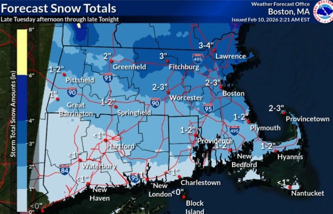
UPDATE: A fast-moving storm is set to hit Rhode Island later today, bringing up to 2 inches of snow to the northern two-thirds of the state, according to the National Weather Service. The snow is expected to begin this afternoon, February 10, and continue into the night, adding to the existing snowpack that has yet to thaw.
The storm is projected to deliver 1 to 2 inches of snow across most of Rhode Island, while the southern region will likely experience a mix of rain and snow, accumulating less than an inch. Forecasters indicate that neighboring parts of Massachusetts and the northeast could see between 3 to 4 inches of snow.
This snowfall will compound the nearly 10 inches of snow already blanketing the Providence area, a result of severe cold spells that have persisted through January and February. Notably, Providence has recorded over 20 inches of snow this January alone, with an additional 2.6 inches so far this month.
February has seen an average temperature of 19.9 degrees, making it 10.5 degrees colder than normal. January temperatures were also below average, registering at 27.4 degrees, which was 2.8 degrees colder than usual.
However, relief from the extreme cold is on the horizon, with temperatures expected to reach a high of 34 degrees in Providence today, and forecasted highs between 35 and 36 degrees through Saturday.
As residents prepare for today’s snow, meteorologists are already monitoring the potential for another coastal storm this weekend, which could bring additional snow and impacts.
Stay tuned for updates as conditions develop. This is a critical time for local residents to stay informed and prepare for winter weather impacts!