Strong Storms Return Tonight Across Southern US Bringing Flood Threat
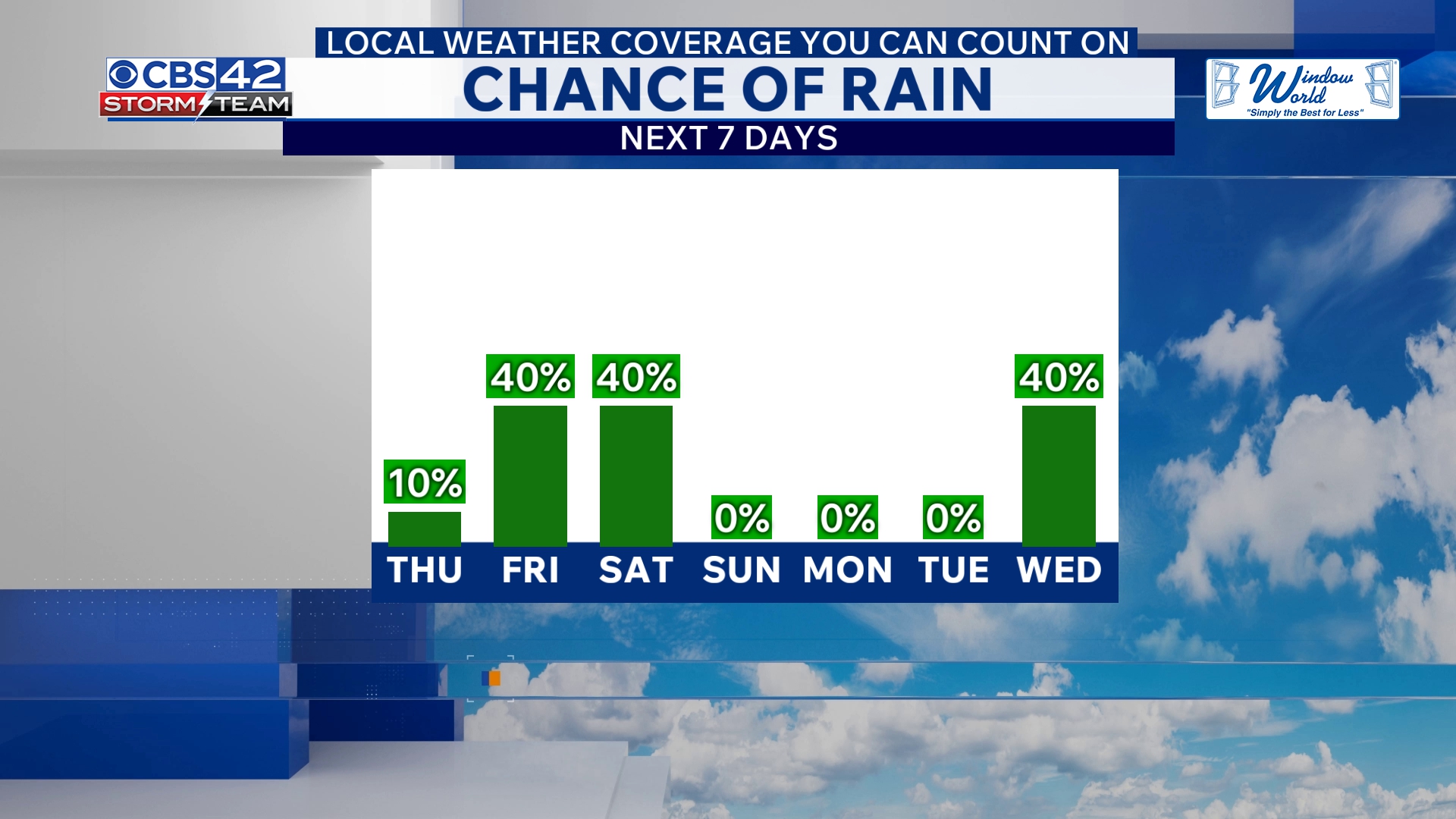
Strong to severe storms are moving in again tonight, fueled by a slow-moving cold front and an upper-level disturbance sliding west to east, according to the CBS 42 Weather Livestream Channel. This system will trigger another round of intense showers and storms primarily along and south of Interstate 20, with large hail and damaging winds posing the greatest risk under a Marginal Risk (Level 1 of 5) for severe weather.
Temperatures will drop to the lower to mid-50s overnight as the rain intensifies. Experts say many areas could pick up 2 to 3 inches of rainfall by the time precipitation ends, offering much-needed respite amid drought conditions that have gripped parts of the Southern and Southeastern United States.
Midweek Drier Break Before More Rain Hits Friday
Thursday will bring a brief drying trend as the cold front continues its push toward the Gulf Coast. Rain should taper off in the morning hours, giving way to partly cloudy skies and cooler weather with highs settling in the mid-70s. However, relief is short-lived.
By Friday, an area of low pressure will advance along the stalled coastal boundary, setting the stage for scattered showers and some non-severe thunderstorms. Temperatures will turn cooler, with highs reaching only the upper 60s. The rain and storm threat will intensify late Friday into Saturday morning, prompting another round of wet weather and gusty winds.
Weekend Weather: Lingering Showers to Clearing Skies
Showers may linger into Saturday morning before skies gradually clear in the afternoon, offering a brighter but still cool day with highs in the upper 60s. Saturday night is expected to be mostly clear and colder with overnight lows dipping into the 40s. Sunday will bring a welcome break with dry, sunny conditions and temperatures climbing back into the upper 60s.
Why This Matters Now
This ongoing weather pattern has immediate consequences for millions of Americans dealing with drought and fire risks. The potential for large hail and damaging winds, while limited in scope, demands vigilance, especially for communities along and south of I-20.
Flooding concerns rise as areas see several inches of rain in a short time span, potentially straining local drainage and infrastructure. Emergency services and residents should prepare for rapidly changing conditions as storms develop and move through.
What to Watch For
Stay informed with local weather briefings tonight and into Friday. Mariners and travelers should note the cooler, wetter conditions with scattered storms impacting road and air travel. Keep an eye on official updates from the CBS 42 Weather Livestream and the National Weather Service for real-time severe weather alerts.
This latest storm track is part of a broader unsettled pattern expected to last through the weekend with a mix of lingering showers and cooler temperatures—typical for spring and early summer transitional weather but important for planning outdoor activities.
CBS 42 Weather Livestream Channel: “The severe risk remains low but includes marginal threats for large hail and damaging winds mainly across southern zones.”
For Nevada residents and travelers, while direct impacts are limited due to distance from this southern system, these weather developments reflect nationwide instability and should remind all to keep emergency kits ready and stay alert to shifting forecasts.
In a year already marked by extreme weather events, this renewed storm activity underscores the ongoing challenges facing the US from drought, flooding, and storm hazards. Monitoring these developments will be key to staying safe in affected regions throughout the next several days.