Historic Tornado Outbreak Pattern Emerging Across Great Plains and Great Lakes
Meteorologists warn of a potentially historic surge in severe weather and tornado outbreaks from the Great Plains extending to the Great Lakes as the final days of May unfold. The latest forecast models show increasing signs of an explosive pattern not seen since the infamous 2004 tornado season, raising alarm for residents in numerous states stretching from the central United States to the Mississippi Valley.
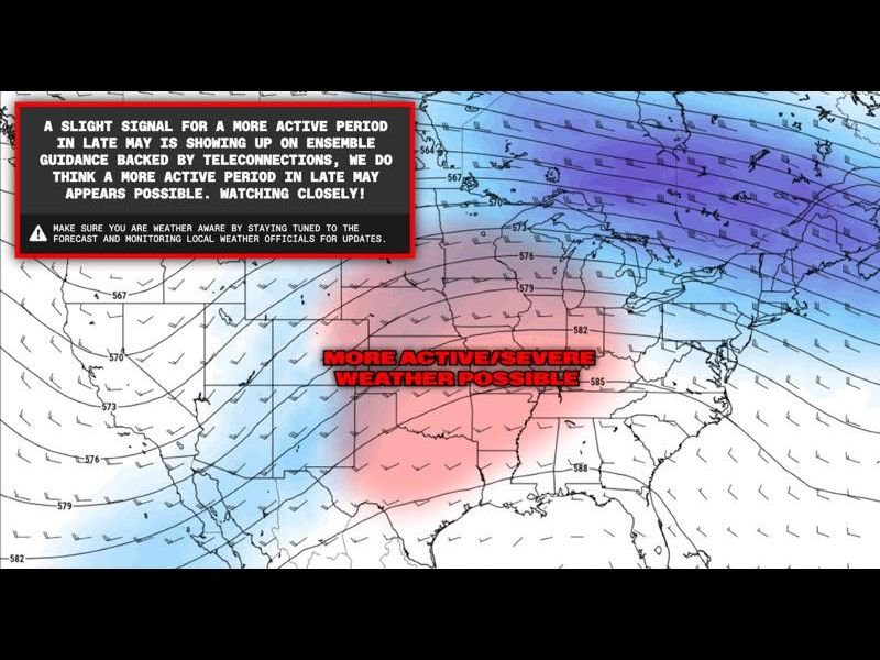
The trusted Euro Ensemble model, a key long-range weather forecasting tool, has flagged a growing risk of intense severe weather outbreaks in late May 2026. Multiple runs of this model confirm a persistent pattern that could trigger widespread tornado activity and dangerous storms in the coming days.
Textbook Atmospheric Setup Fuels Severe Weather Potential
The driving force behind this outbreak threat is a classic trough-ridge atmospheric pattern firmly establishing itself across the continental U.S. This configuration creates the perfect environment for tornado formation by combining strong wind shear, moisture influx, and atmospheric instability.
May 7 model analyses reveal a 500mb wind pattern primed to fuel severe thunderstorms and long-track tornadoes predominantly over the central and southern plains, with the threat stretching northeast into the Great Lakes corridor. Experts emphasize this setup is among the most reliable precursors to major tornado events recorded historically.
Potential Replay of Devastating 2004 Tornado Season
The severity of the forecast has prompted meteorologists to draw comparisons with the 2004 tornado season, known for its sustained, violent tornado activity across multiple states. Should current atmospheric signals verify, late May through June could usher in a period marked by numerous significant tornado outbreaks, increasing risk to communities across a broad swath of the U.S.
Residents from the Great Plains to the Great Lakes must remain vigilant as this pattern unfolds, especially given the potential simultaneous threat across multiple states. Officials urge everyone in the affected regions to review safety plans and ensure all weather alert systems are operational.
Preparing for an Active Severe Weather Period
The National Weather Service and meteorological agencies are closely monitoring this rapidly evolving situation. With five to ten days remaining in May, the risk of explosive severe weather escalates daily. Residents should keep tuned to local forecasts and emergency bulletins.
Often overlooked outside traditional tornado alley, states near Nevada and across the Midwest are watching developments closely as these powerful systems could influence weather patterns nationwide.
For continuous updates and storm coverage, readers can follow specialized tracking and detailed analysis at SaludaStandard-Sentinel.com, offering real-time guidance as the situation develops.
Why This Matters to Nevada and Nationwide
While Nevada itself sits outside the primary outbreak zone, the potential scale of this event signals broader climatic shifts impacting atmospheric circulation patterns that connect nationwide weather dynamics. Additionally, residents with family or travel plans in affected areas should pay careful attention to warnings.
Thunderstorms and severe weather outbreaks of this magnitude often disrupt transportation networks, agricultural operations, and emergency services far beyond the immediate tornado zones. Preparedness across all states remains critical.
What’s Next?
Forecasters will update models daily as the late May timeframe approaches. The risk window could expand or contract, but the current signals demand immediate public preparedness.
Communities across the Great Plains to Great Lakes region should remain alert and proactive in the coming days — this could develop into one of the most active and dangerous tornado periods in over two decades.
“The atmospheric conditions are aligning in a textbook pattern known to spawn significant tornado outbreaks,” said a senior meteorologist monitoring the Euro Ensemble model results. “We encourage everyone in the risk zones to have their safety plans ready and stay tuned for rapidly changing forecasts.”
Stay with The Nevada Voice for ongoing severe weather coverage and latest updates impacting Nevada and nationwide.