Giant 3.54-Inch Hailstorm Pummels Lake Amistad as Supercell Moves Toward Del Rio
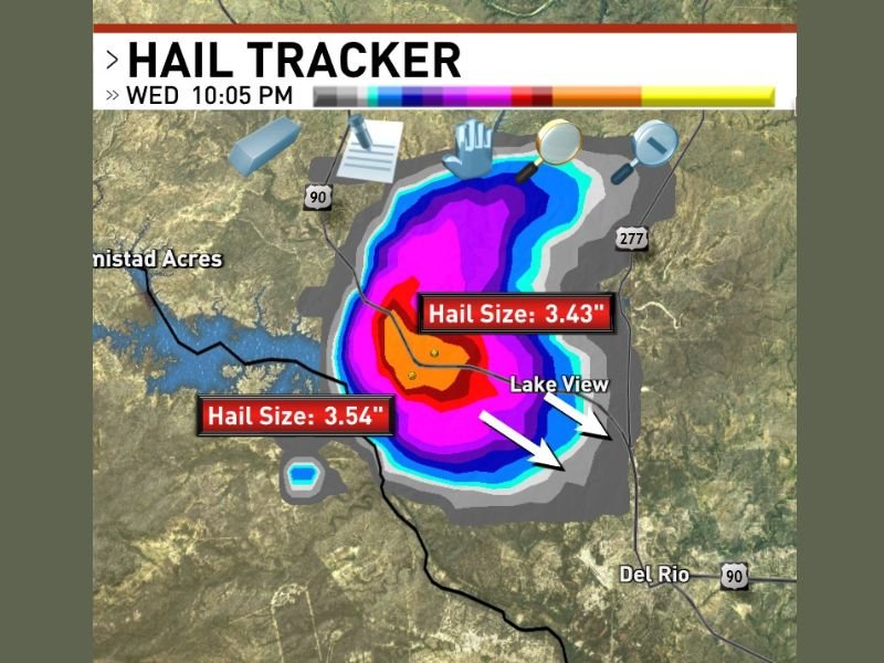
A powerful supercell thunderstorm unleashed massive 3.54-inch hail over Lake Amistad, Texas, at 10:05 PM Wednesday, sparking urgent threats to nearby communities including Del Rio, Lake View, and Amistad Acres. This extreme hail event ranks among the largest recorded in the ongoing severe weather outbreak sweeping southern Texas.
Hail Tracker technology revealed two giant hailstone readings within the storm’s core at 3.54 inches and 3.43 inches in diameter, confirming the supercell as one of the most destructive hail producers active in the region’s current severe weather pattern.
Catastrophic Damage Risk as Hailstorm Advances Southeast
The supercell’s intense hail core was centered directly over Lake Amistad at the time of confirmation, with vivid red and magenta radar returns highlighting the densely concentrated hail region within the storm’s updraft. Hailstones this large have catastrophic destructive potential — capable of penetrating vehicle roofs, shattering windshields, ripping apart residential and commercial roofing, and posing severe life-threatening hazards to anyone outdoors.
As the supercell tracked southeast from Lake Amistad, the cities of Del Rio, Lake View, and Amistad Acres fell directly in the storm’s path. The broad hail swath captured showed damaging hail extending beyond the core, threatening a wide area with significant property damage risk, particularly in the Del Rio urban corridor, one of the largest communities in the region.
Back-to-Back Storms Compound Severe Weather Impact
Authorities noted this was at least the second giant hail-producing supercell hitting the area within hours, marking an extremely active and destructive severe weather evening for southwestern Texas. The consecutive supercells have compounded damages and heightened public safety concerns across the Del Rio and Lake Amistad corridor.
Emergency management officials remain on high alert as the weather pattern remains unstable, with further storms possible. Residents in the threatened zones have been urged to seek shelter immediately and avoid outdoor exposure.
Why This Matters Now
While this massive hailstorm occurred hundreds of miles from Nevada, severe weather like supercell hailstorms are increasingly impacting broader U.S. regions with escalating intensity, a trend prompting urgent attention to storm preparedness and response nationwide. Nevada’s residents, especially in high-risk areas, should stay informed as the 2026 storm season unfolds.
The destructive potential of giant hail emphasizes the importance of monitoring live weather updates through reliable sources. The severe weather outbreak currently affects southern Texas with implications for infrastructure, emergency services, and public safety.
What’s Next
Residents in the path of this storm should continue to monitor local warnings closely. Authorities advise remaining indoors until the storm passes and to report any damage or injuries promptly.
The Nevada Voice will continue to track severe weather developments nationwide with expert storm analyses and real-time updates to keep our audience safe and informed.
“Hail of this magnitude is rare and extremely dangerous—people must take shelter immediately,” said local meteorologists tracking the storm.
For live updates on severe weather across the U.S., stay tuned to The Nevada Voice and official weather channels.